
Are you still operating status-quo even as the industry changes around you? Are you taking advantage of every opportunity to feed your business as you feed the world?
Have you ever stopped to think about what goes into accurate field monitoring and yield forecasting? Or what makes certain conservation practices in your fields work better than others? Or how irrigation systems know how to precisely apply water to hundreds of acres of row crops?
The answer is simple, right? Satellite data.
The phrase has become a cliché. But “satellite data” is actually more than a catchphrase—it involves more than just blips on radar. It’s at the heart of just about everything related to precision agriculture these days. Satellite data is here to stay, and it’s brought to you by NASA.
“NASA satellites are the world’s premier satellites,” says Bradley Doorn, Program Manager for the Agriculture Earth Action Program at NASA. “These satellite programs are funded by tax dollars, so they should be put to work to really, really benefit the taxpayers. On top of that, these satellite and data capabilities are extremely cool.”
Generating satellite data is a Herculean effort. Individual bits of information about the planet are harvested, beamed thousands of miles up to satellites orbiting in outer space, then beamed back down to Earth. From there, that data is interpreted and used to affect big-picture issues such as improving agricultural sustainability, lessening food shocks, mitigating the effects of climate change, and even helping determine agricultural trade policy.
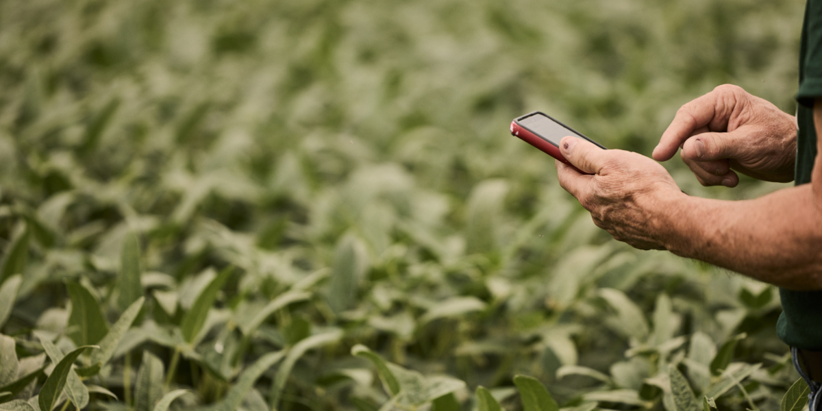
Satellite data gives modern farmers an edge that their predecessors simply didn’t have.
On the ground and in the field, satellite data can be used to calibrate equipment, improve irrigation timing, monitor soil health, detect crop disease, manage pests, and schedule fertilizer application.
Information is Ag’s New Secret Weapon
Agriculture has come a long way in the past 50 years, and recent technological changes have the industry moving at warp speed.
Prior to satellite data availability, farming depended on the analysis of past patterns and events and suggestions from trusted sources such as Extension. Decisions about what to plant, when, and how much were driven largely by farmers keeping records on paper and talking to other farmers before making decisions about the next year’s crop.
Today, NASA satellite data makes it possible to observe conditions directly and nearly in real time. Instead of relying on information about what has happened, decisions are now made based on what is happening. This move to high-quality, up-to-the-minute information is a game-changer.
Data Can Lower Costs, Instill Higher Confidence
“In precision or digital agriculture, NASA science and research is at the foundation of information used by equipment manufacturers and commercial satellite and data providers,” says Doorn. “By tapping scientific advances developed by NASA for space programs, manufacturers and providers are ultimately able to provide products and services at lower costs to consumers than if they developed this technology independently. This is cost-effective for the producers, and it’s something they can have confidence in.”
Plowing Through the Data
Technology is always evolving. The beauty of this is that new data can be fine-tuned and tailored to improve technology for Illinois soybean growers.
“We’ve had discussions with all the commodity groups, including the American Soybean Association,” says Doorn. “In fact, one of the things we do at Commodity Classic is to set up times for my leadership at NASA to meet with the commodity associations to hear their concerns and challenges.”
“Different commodity producers have different issues and needs. Some might be extremely concerned about water issues like drought. Others might be focused on disease and pest control. It’s important that we hear them out, take time to really listen to their concerns,” Doorn says. “Plus, we can share insights on what we see coming online, the things that might impact their production decisions.”
With so many moving parts, the information-sharing doesn’t end there.
“This collaborative approach helps keep NASA laser-focused on doing what’s relevant and important to those associations and their stakeholders,” Doorn says. “Plus, by hearing about the innovations or new technologies or complementary research they’re doing, we can be more in sync with each other, and not redundant.”
In other words, these sophisticated technologies and solutions depend on free and open communication—actual discussions among humans.
“Let’s say we NASA folks have an idea. If we can detect and understand a particular issue really, really well, then we’ll want to test our idea out. So, we get it in front of Extension, consultants, commodity groups, the folks on the ground. They might come back and say, ‘That will help us.’ Or, ‘This is great for big farms, but it doesn’t work here.’ Or ‘This works for the big irrigators, but not for the rain-fed.’ That’s why it’s so important to make sure we’re having the right discussions at the right levels,” Doorn says.
‘One Small Step for Man’
“One of the things that we need to work on in the coming years is to take this information and technology out of the research realm and put it into the hands of practitioners on the ground, the producers and decision-makers. Once they start playing with it, it won’t be theoretical for them anymore. They’ll get to experience it as the cool ride that it is. They’ll get to experience what they didn’t know was even possible. Plus, they can play an important part in refining and improving it, working out the kinks, to make it even more useful,” Doorn says.
“But first, we’ve got to get this information in front of them. We can’t simply send out briefings and expect this process to work. We need to work shoulder-to-shoulder with these groups,” Doorn says. “That’s the big challenge coming up in the next few years.”
“The big takeaway here is that your nation’s space program has an agriculture program. And the farming community—the producers and associations and agricultural stakeholders—should take advantage of it,” says Doorn. “There are a lot of different players involved, and the opportunities are infinite if we just collaborate and work together.”
With insights from NASA’s public data, the right collaborations, and the practicality of making it all work at the farm level, these advances can take agriculture to infinity and beyond.
Cutting-edge research is underway in these University of Illinois collaborations with NASA
Illinois is the leader in soybean production in the U.S. It’s also a leader in key research and innovation focusing on soybeans. NASA and the University of Illinois are teaming up to apply advanced NASA technology and satellite data to soybean research that addresses critical agricultural challenges.
- Through the NASA Acres program, the University of Illinois is working with nine other universities to focus on 14 programs designed to convert satellite data into useful information for farmers.
- Researchers from the University of Illinois collaborated with Darren Drewry of NASA’s Jet Propulsion Laboratory on an advanced vegetation model to show how soybean plants could be modified to produce higher crop yields with lower water consumption while also offsetting greenhouse gas emissions.
- University of Illinois researchers are using NASA satellite data together with ground sampling and hyperspectral imaging to determine optimal nitrogen levels for crops. Kaiyu Guan, professor and chief scientist for NASA Acres, is leading the project.
- University of Illinois researchers worked NASA’s Drewry on sophisticated modeling to study how photosynthesis in soybeans is enhanced by variations in chlorophyll levels.
Recent Articles
In this "Illinois Game Changers Issue" Illinois Field & Bean highlights progress at the Soy Innovation Center we well as other game-changing agriculture advancements.
By
You don't need to be a spreadsheet genius to be a successful farmer. Instead, focus on these first principles.
By IL Field & Bean Team